
Savannakhet
Savannakhet
ເມືອງໄກສອນ ພົມວິຫານ | |
|---|---|
District and municipality | |
| Kaysone Phomvihane District | |
 The commercial centre of Kaysone Phomvihane, Savannakhet Province | |
 Savannakhet | |
| Coordinates: 16°33′N 104°45′E / 16.550°N 104.750°E | |
| Country | |
| Province | Savannakhet Province |
| Population (2018) | |
• Total | 125,760 |
| Time zone | UTC+7 (ICT) |
Savannakhet (Lao: ສະຫວັນນະເຂດ, RTGS: Sawannakhet, pronounced [sā.wǎn.nā(ʔ).kʰȅːt]), officially named Kaysone Phomvihane (Lao: ໄກສອນ ພົມວິຫານ); since 2005 and previously known as Khanthaboury (Lao: ຄັນທະບູລີ, RTGS: Khanthaburi), is a city in western Laos. It is the capital of Savannakhet Province. It has a population of 125,760 (2018).[1] The annual per capita income of Kaysone Phomvihane City is US$2,041 (2018).[1]
Name change
[edit]The settlement of Savannakhet was formerly called Khanthaboury. Then it became Savannakhet. Its name was changed to Kaysone Phomvihane in 2005, while retaining its status as the provincial capital of Savannakhet Province. The city is the birthplace of Kaysone Phomvihane, the first leader of Laos from 1975 to 1992 after the dissolution of the Kingdom of Laos. In 2018, its status was upgraded to that of a "city". In order to attain city status, a district or municipality must be financially self-sufficient and have a population of at least 60,000 persons.[1]
Climate
[edit]| Climate data for Savannakhet (1991-2020) | |||||||||||||
|---|---|---|---|---|---|---|---|---|---|---|---|---|---|
| Month | Jan | Feb | Mar | Apr | May | Jun | Jul | Aug | Sep | Oct | Nov | Dec | Year |
| Record high °C (°F) | 38.5 (101.3) |
39.5 (103.1) |
42.0 (107.6) |
41.5 (106.7) |
41.2 (106.2) |
38.0 (100.4) |
38.5 (101.3) |
36.3 (97.3) |
36.3 (97.3) |
36.0 (96.8) |
36.5 (97.7) |
38.0 (100.4) |
42.0 (107.6) |
| Mean daily maximum °C (°F) | 29.7 (85.5) |
31.8 (89.2) |
34.2 (93.6) |
35.1 (95.2) |
33.9 (93.0) |
32.5 (90.5) |
31.2 (88.2) |
30.9 (87.6) |
31.4 (88.5) |
31.1 (88.0) |
31.2 (88.2) |
28.6 (83.5) |
31.7 (89.1) |
| Daily mean °C (°F) | 22.2 (72.0) |
24.4 (75.9) |
27.4 (81.3) |
29.0 (84.2) |
28.8 (83.8) |
28.4 (83.1) |
27.4 (81.3) |
27.2 (81.0) |
27.3 (81.1) |
26.1 (79.0) |
24.3 (75.7) |
21.9 (71.4) |
26.2 (79.2) |
| Mean daily minimum °C (°F) | 15.8 (60.4) |
17.9 (64.2) |
21.7 (71.1) |
24.1 (75.4) |
25.0 (77.0) |
25.3 (77.5) |
24.6 (76.3) |
24.5 (76.1) |
24.2 (75.6) |
22.0 (71.6) |
19.2 (66.6) |
16.2 (61.2) |
21.7 (71.1) |
| Record low °C (°F) | 5.8 (42.4) |
9.0 (48.2) |
10.0 (50.0) |
15.0 (59.0) |
17.5 (63.5) |
19.0 (66.2) |
18.2 (64.8) |
18.0 (64.4) |
18.0 (64.4) |
12.0 (53.6) |
8.5 (47.3) |
7.0 (44.6) |
5.8 (42.4) |
| Average precipitation mm (inches) | 3.3 (0.13) |
19.3 (0.76) |
40.6 (1.60) |
69.3 (2.73) |
206.2 (8.12) |
216.5 (8.52) |
307.1 (12.09) |
333.9 (13.15) |
239.3 (9.42) |
74.2 (2.92) |
7.3 (0.29) |
4.0 (0.16) |
1,521 (59.88) |
| Average precipitation days (≥ 1.0 mm) | 1 | 2 | 4 | 6 | 13 | 14 | 18 | 19 | 15 | 7 | 2 | 1 | 100 |
| Average relative humidity (%) | 69 | 68 | 65 | 67 | 75 | 78 | 80 | 83 | 81 | 76 | 72 | 70 | 73.7 |
| Mean monthly sunshine hours | 246.8 | 222.4 | 225.6 | 217.4 | 191.2 | 165.0 | 142.1 | 115.9 | 154.6 | 202.8 | 225.3 | 236.9 | 2,345.9 |
| Source 1: NOAA (humidity, 1961-1990 and extremes)[2][3][4] | |||||||||||||
| Source 2: The Yearbook of Indochina (1932-1933)[5] | |||||||||||||
-
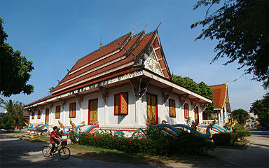 Wat Sainyaphum
 -
 Chinese Buddhist Temple
 -
 Vietnamese Buddhist Temple Diệu Giác
 -
 St. Teresa's Catholic Church


References
[edit]- ^ a b c Yap, Jasmina (28 May 2018). "Town of Kaysone Phomvihane Officially Declared a City". The Laotian Times. Retrieved 30 May 2020.
- ^ "World Meteorological Organization Climate Normals for 1991-2020 — Savannakhet". National Oceanic and Atmospheric Administration. Retrieved 17 January 2024.
- ^ "Savannakhet Climate Normals 1961–1990". National Oceanic and Atmospheric Administration. Archived from the original on 17 July 2020. Retrieved 29 November 2013.
- ^ "Global Surface Summary of the Day - GSOD". National Oceanic and Atmospheric Administration. Retrieved 26 January 2023.
- ^ The Yearbook of Indochina (1932-1933)
External links
[edit] Savannakhet travel guide from Wikivoyage
| International | |
|---|---|
| National | |
| Other | |